
Trace a Summerville Street Address
A street search in Summerville works best as an address-to-document sequence. The Town reaches into Dorchester, Berkeley, and Charleston county systems, so a postal city alone is not enough to select a records office. For an address in Dorchester County, the first official stop is the current property record. Its parcel number, account number, short legal description, subdivision, and last-sale reference supply identifiers that remain useful after a street name becomes ambiguous. A recorded owner is a property connection, not an automatic statement about present occupancy.
- Check the full street name, direction, type, alias, and range in the Town master-street list before searching.
- Use the Dorchester CAMA inquiry with the street name, then add number or type to narrow the parcel rows.
- Open the parcel card and save the TMS or account number, subdivision, short legal description, and last-sale deed book and page.
- Use County GIS to place that parcel on the street and distinguish its geometry from nearby parcels.
- Use the book and page, parties, date, and legal description in the ROD index. For older household evidence, ask the library to identify a specific dated directory or telephone book before relying on it.
That order prevents a common error: treating a name returned by a parcel query as a roster for the whole street. It also gives the next custodian a precise request if a web result is incomplete. Note: Keep the date checked with each result because the county warns that a recorded item may still be processing.
Summerville Street Prefixes and Ranges
The current Summerville master-street list is a practical first record, not just a map aid. Revised April 24, 2026, it has fields for prefix, street name, type, suffix, full name, city, ZIP, location, range, alias, and council district. Its numbered streets use separate east and west prefixes. It also records aliases such as First North Street East. Dropping a direction from a query can join different street segments that only share a base name.
ZIP is another useful warning flag. The list shows that some east-side ranges use 29485 while many downtown segments use 29483. That does not make a ZIP a county or municipal boundary. Use the range and alias to form a clean CAMA query, then let the parcel and GIS records establish jurisdiction. The street list is a current public-safety reference, so it should not be used to claim a historical renumbering date that has not been verified.
Summerville Street Directory Parcel Searches
The Dorchester CAMA property inquiry is the closest official street-by-street tool for the Dorchester portion of Summerville. A street name alone can return parcel rows. Adding a street number or street type narrows the result. The initial grid identifies parcel and account numbers, owner name, subdivision, street address, and unit. It is useful for locating parcels along a street, yet it does not supply every person associated with a location.
| Query field | Entry type | How it works |
|---|---|---|
| Tax Year | Text | Four digits; a blank field defaults to the current tax year. |
| TMS or Account Number | Text | Use the saved parcel identifier when a street query returns several rows. |
| Owner Name | Text | Last name for a list, or last and first name for an individual. |
| Street Number and Name | Text | Use the verified number and full street wording from the master list. |
| Street Type | Select | Choose the listed type instead of assuming the abbreviated form. |
| Sales Date Search | Date and property fields | A separate mode for property and transaction characteristics, not an address roster. |
For a whole street, record enough to distinguish parcels before following any name. The Assessor says current-day changes display within 24 hours, but the data are not certified for engineering or land conveyance. Treat the result as a locator, then verify a material ownership question through the recorded instrument.
Read a Summerville Parcel Card
A parcel card separates facts that are easy to blur in a quick street directory search. It can display the parcel number or TMS, account number, owner name, owner mailing address, situs street address, subdivision, unit, short legal description, and sales-history fields. The last-sale panel can add deed book, deed page, sale date, sale price, grantor, grantee, and recorded date. Those fields create a trail to the ROD. They do not convert a mailing address or a tax classification into proof of who is physically present at the property.
- Parcel or TMS
- The county identifier for a piece of land. It is the best key for keeping similarly named street addresses apart.
- Situs address
- The physical location used by the assessor and GIS. It differs from the address where an owner receives correspondence.
- Plat
- A recorded map or plan that can identify lots, blocks, boundaries, and subdivisions. Read it with the related deed reference.
- Criss-cross directory
- An address-to-name section in a dated directory volume. No verified Summerville-wide run was found, so inspect a specific volume before using it.
Map a Summerville Street Segment
Dorchester Maps and GIS provides Online Mapping, Property Lookup Without Mapping, GIS Data Layers, a glossary, map requests, and data-order routes. Start with the CAMA address or TMS, then use the map to place the selected parcel within the street pattern and see the available district or boundary context. The public parcel service identifies its data source as Dorchester GIS and Assessor CAMA data. It is useful for location and parcel relationships, not a certified boundary or title opinion.
The recorded geometry matters on curving streets, cul-de-sacs, and access roads. A visually close parcel is not necessarily connected to the selected land. Return from the map to the individual property card, then to the deed or plat when a boundary or ownership question matters. The GIS office lists a Summerville location at 500 N. Main Street and publishes map and data-request channels for needs not met by the viewer.
The Town Archive Center search shows how municipal material is organized by category and date. Its annexation, docket, and CitizenServe categories can point to an address-linked public process. A municipal result may name an owner, applicant, contractor, engineer, or agent, so the party role must be read before making any conclusion.
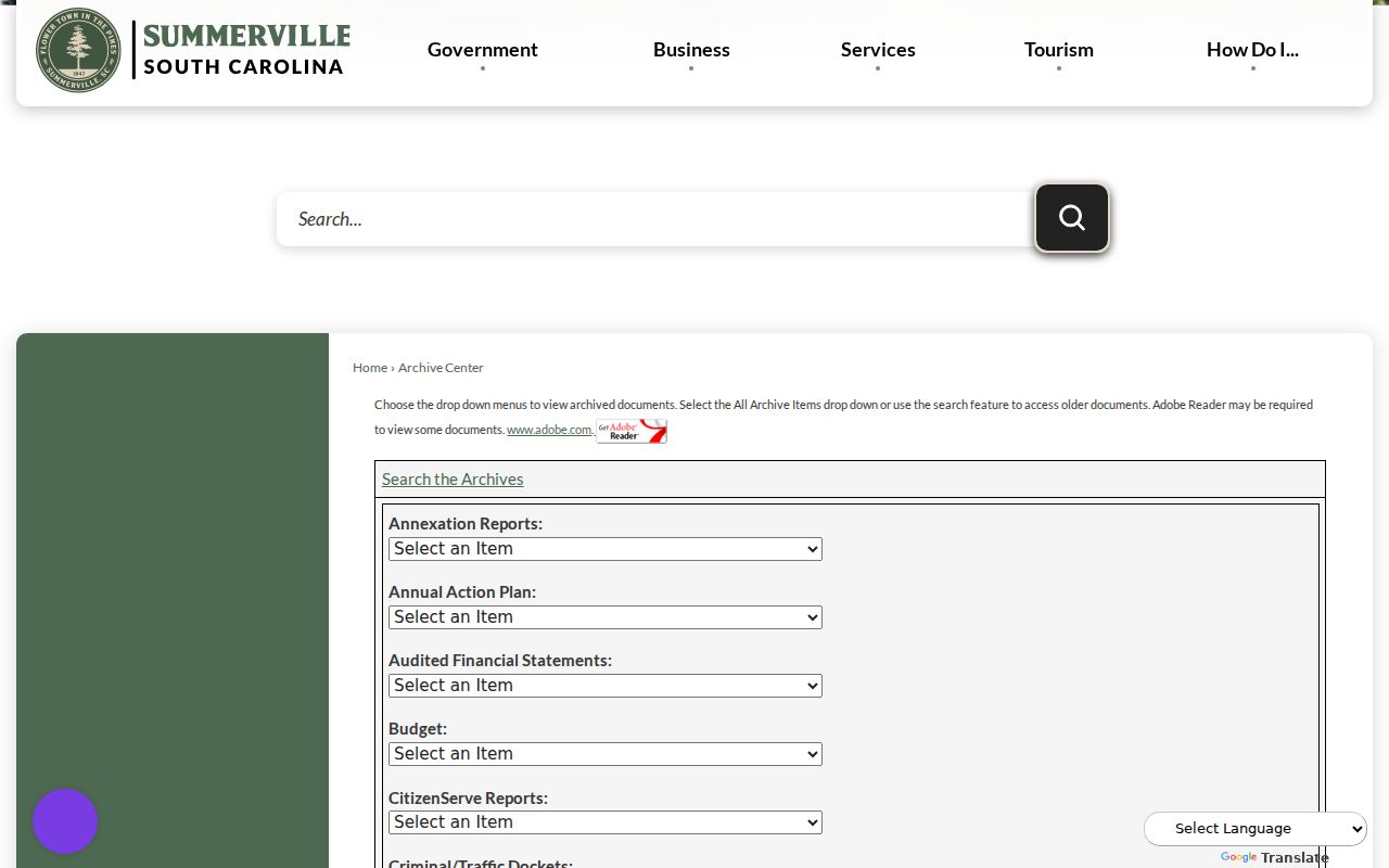
Archive categories add context and dates to a parcel trail. They do not replace the assessor card, the ROD image, or a confirmed legal description.
Deeds Behind a Summerville Street
Use the CAMA last-sale book and page as the handoff to the Dorchester Register of Deeds name search. The ROD indexes parties, dates, categories, entity types, and book or file references. A street address itself is not the primary key. Match the selected item through its legal description, lot or block, subdivision, TMS, plat reference, or attached document. Search a prior seller as a grantee when tracing an earlier acquisition, while keeping the same land description in view.
| Index detail | Why it belongs in the address file |
|---|---|
| Date and Code-Book-Page | Locates the specific recorded item and its sequence in the trail. |
| Type and Description | Distinguishes a deed from a plat, restriction, lien, right of way, or another instrument. |
| Party 1 and Party 2 | Names parties, but the image must confirm their role rather than column order alone. |
| Image or PDF link | Allows the document text and legal description to be checked when an image is available. |
The ROD’s standard search removes spaces, punctuation, and special characters from alphabetic names. Its help also says names beginning with an article can be found with or without that article. That can help with a historical trust or entity name, but it does not remove the need to compare the land description and document type.
See the official grantor-grantee search before using its fields. The screenshot shows the date, category, entity, and party controls that support a narrow document search.
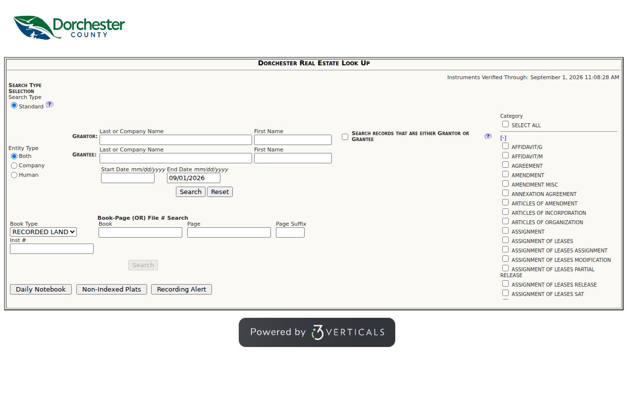
Once a deed is found, record the party roles and legal property clues rather than treating every index hit as a statement about a street household.
Summerville Street Archive Records
Address-linked municipal records can fill a date gap without replacing the land trail. Town Archive Center categories include CitizenServe Reports and annexation reports, and Town staff provide Building Permits and Code Enforcement contact routes. If an address is on the edge of Town service, the annexation history can explain why a municipal record begins later than the county title record. A Town annexation requires a petition supported by recorded deed and plat material, review, and an ordinance, followed by notices to 911, fire, and tax offices.
For a missing public file, a narrow request through the Dorchester County FOIA portal should name the parcel or TMS, the date span, and the exact document sought. South Carolina FOIA does not require staff to construct a title chain. A request that starts with a precise address record is more likely to reach the right department.
Summerville Street Voting Limits
There is no public MyscVOTES screen for browsing people by street. The official MyscVOTES registration check requires a name, county, and date of birth matching the registration card. It is an individual verification route. South Carolina Code § 7-5-170 makes official registration records available for citizen inspection, while the State Election Commission has a controlled voter-list program with eligibility, criteria, and use limits.
For a lawful geographic request, first verify the county and current precinct context, then contact the Dorchester County Board of Voter Registration and Elections about the applicable record process. The individual portal cannot be repurposed into a street list. A no-match can reflect a county or date-of-birth mismatch, an inactive or protected status, a recent move, or no registration. It does not establish that a person is absent from an address.
Older Summerville Street Evidence
No locally verified reverse or criss-cross directory run was located in the research. The honest historical route is to ask the Dorchester County Library reference desk for a particular city directory, telephone book, cross directory, microfilm item, or catalog record, using the street and time period. If a volume is found, record its publisher, year, entry format, and whether it has a reverse section. A conventional directory runs from name to address; a reverse section runs from address to name. Neither is a complete household record.
For a pre-1897 land trail, the South Carolina Archives holds Dorchester conveyance books beginning with county formation, plus Berkeley conveyance transcripts from 1885 to 1897 and Colleton transcripts from 1867 to 1897. This parent-county bridge matters when a present Dorchester parcel leads to a deed that predates the county. It is a records-geography issue, not proof that the title chain is broken.
Summerville Street Directory Records
A useful Summerville street directory keeps each source in its own lane. CAMA connects a street query to a parcel. GIS establishes parcel placement. The ROD supplies recorded instruments and legal property references. Town records can date a public process. The library and archives may contribute historical context once a particular source is confirmed. This division is what lets an address search stay accurate when a name, mailing address, or map label appears to conflict.
| Address record | Local keeper | Best use | Access boundary |
|---|---|---|---|
| CAMA parcel card | Dorchester Assessor | Parcel, owner association, situs and mailing fields, sales pointer | Street, owner, TMS, or account search; not certified or a household list. |
| GIS parcel view | Dorchester GIS | Parcel geography, districts, and street placement | Online Mapping or no-map lookup; confirm a legal boundary separately. |
| Recorded instrument | Dorchester ROD | Parties, date, book/page, legal description, and image where available | Name, date, category, or book/file search; archive library fallback. |
| Town archive or permit file | Town of Summerville | Public project, code, annexation, or docket context | Archive search, department contact, or a focused records request. |
| Historic tax and conveyance books | South Carolina Archives | Older land and taxpayer references | Use the dated Dorchester and parent-county record groups. |
The chain begins with an address but becomes more reliable when it carries the parcel identifier and legal description forward. If the objective changes from a street to one named person, the resident lookup route uses a different, person-by-person verification method.
Limits of a Summerville Street Directory
Property records identify an owner association, not all people at a location. The public workflows reviewed do not provide utility-customer data, a complete household list, or an open street-browse voter display. Mailing address, situs address, and legal description answer different questions and can legitimately differ. Protected address programs, inactive voter status, confidential court material, and statutory privacy exemptions also limit what a public record displays. A missing result should never be used to infer a person’s location.
Lawful use. Use address records for personal, family-history, property-history, or civic research. Do not use a street search to stalk, harass, intimidate, or harm anyone.