
Summerville Neighbors by Parcel
The records used around a Summerville address each answer a narrower question. County GIS establishes parcel geometry and possible adjoining lots. The Assessor’s CAMA inquiry holds the current parcel and recorded-owner fields. The ROD explains deeds, plats, restrictions, and other recorded instruments. Election and community channels have different limits. Together, these sources can describe a property-centered block check without turning it into a list of people.
| Source | What it shows about a block | Access |
|---|---|---|
| Dorchester Maps/GIS | Parcel geometry and nearby or apparently adjoining parcels | Online mapping from an address or TMS; confirm the shared boundary. |
| Assessor CAMA | Recorded owner, mailing and situs fields, account/TMS, and sale pointers for each parcel | Search each parcel separately; owner does not equal occupant. |
| Register of Deeds | Deeds, plats, restrictions, and recorded association-related instruments | Name, book/page, date, and category routes; read party roles and document type. |
| Election records | Authorized registration inspection or controlled list process | County Board or State Election Commission procedure, subject to eligibility and use limits. |
| Town Planning | Public neighborhood, annexation, zoning, and meeting context | Public planning material and contact channels; no verified member directory. |
| Brownsville Civic Association | A named association in Town planning material | No official public contact or member directory was located in the reviewed sources. |
The central distinction is owner versus occupant. A property card may display an owner’s mailing address and a situs address, but those are separate fields. Neither field creates a household record. Non-owner occupants, adult relatives, former residents, utility customers, and delivery customers are outside this parcel method.
Set Your Summerville Neighbor Block
Before checking neighbors, normalize the address. Summerville’s public master-street list distinguishes east and west prefixes, address ranges, aliases, ZIPs, locations, and council districts. A search for a numbered street without its E/W prefix can mix separate segments. The list also shows that a street can cross ZIP areas, so postal wording alone is not a parcel or office-of-record test.
The Town’s annexation process confirms that Town territory can involve Dorchester, Berkeley, or Charleston County systems. Establish the parcel’s county before assuming that Dorchester GIS, CAMA, or deeds apply. This matters near an annexation boundary, where a neighboring address can share a postal city but belong to another county’s records.
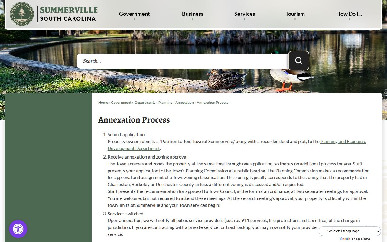
The Town material supports the county-first check. It does not provide a live parcel-neighbor control or a directory of people on a block.
Note: Preserve a street’s directional prefix and listed alias when a map, assessor result, and deed description do not initially match.
Map Adjacent Summerville Neighbor Parcels
The documented adjacent-parcel method begins in CAMA and uses GIS as the geographic check. The county GIS landing page confirms Online Mapping, Property Lookup Without Mapping, GIS Data Layers, a glossary, and map-request and data-order routes. The live interactive parcel-click, buffer, identify, measure, and layer controls were not captured from the official static page. No captured live GIS neighbor controls were available in the reviewed official material, so their exact labels should not be assumed.
- Search the target address or TMS in CAMA and record its parcel number, account number, street address, and short legal description.
- Open the county’s Online Mapping route and locate that parcel by the address, TMS, or its map position.
- Inspect the parcel outlines, identifying only parcels that share a boundary or are geographically contiguous to the target.
- Return to CAMA for every selected parcel and record the owner association, mailing field, situs field, and last-sale pointer separately.
- Use the ROD only when a deed date, plat, restriction, party role, or legal-title question needs confirmation.
A cul-de-sac, access road, rear parcel, or non-linear subdivision can make a visually nearby lot a poor substitute for an adjoining one. The public map is a locator, not a certified survey. For a full named-street record chain rather than an immediate block, the Summerville street directory is the more fitting route.
Read Each Summerville Neighbor Parcel
Each surrounding parcel deserves its own record check. Dorchester CAMA can show a parcel number or TMS, account number, recorded owner, owner mailing address, situs street address, subdivision, unit, legal and geographic fields, last-sale deed book and page, sale date, grantor, grantee, recorded date, land details, improvements, assessment fields, and sales history. That is a rich property inventory, but it remains a property record.
| Parcel-card field | Careful use for nearby parcels |
|---|---|
| TMS and account number | Preserve a precise parcel identifier when moving between CAMA, GIS, and the ROD. |
| Situs and mailing address | Keep them distinct. The mailing field can be correspondence information, not occupancy proof. |
| Short legal description, block, tract, subdivision | Compare the parcel’s legal and map context with an instrument or plat. |
| Last-sale book and page | Use as a pointer to the recorded document, then verify the party roles in that document. |
| Grantor and grantee | Describe the transaction role shown in the sale data, not a current resident conclusion. |
The ROD search supports date, category, entity type, grantor, grantee, and book-page research. A deed search can distinguish a land transaction from another instrument category, but it does not create an address-indexed neighbor roster. Records in process may not be available through the online or in-house systems, according to the ROD’s own caution.
Summerville Neighbor Voter Record Limits
South Carolina makes official registration records public for citizen inspection under S.C. Code § 7-5-170. That rule is different from online display. MyscVOTES requires a matching name, county, and date of birth, so it is an individual registration check rather than a neighbor or street search. A protected or inactive registrant may not appear, and no conclusion should be drawn from a non-match.
The State Election Commission’s list program can apply permitted criteria such as county, voting district, household, participation, and registration date for an eligible registered South Carolina voter. The state’s published list contents include address, precinct, districts, registration information, and participation history. Participation means whether a voter took part in an election, never a ballot choice. For the Dorchester part of Summerville, the county Board of Voter Registration & Elections is at 201 Johnston Street in St. George and lists 843-563-0132 and 843-832-0132.
That process is controlled and carries a use restriction. S.C. Code § 30-2-50 prohibits knowingly obtaining or using public-record personal information for commercial solicitation directed to someone in South Carolina. It is not permission to build a block profile.
Summerville Community Contact Boundaries
Town planning material identifies the Brownsville Civic Association as an association consulted in historic residential-area planning. It verifies the association’s name, not a roster, member address list, or official public contact channel. No official public Summerville neighborhood roster, neighborhood-association directory, or public membership directory was found in the sources reviewed. Other HOAs or neighborhood groups should be named only after their official channel or recorded covenant source is checked.
| Community resource | Verified public route | What the record supports |
|---|---|---|
| Brownsville Civic Association | Town 2026 Comprehensive Plan review reference | A named planning participant; no verified public member directory or contact was located. |
| Town Planning | 200 S. Main Street, 843-851-4213 | Public planning and meeting context, plus an appropriate route to ask for public association information. |
| Dorchester ROD | Official name and instrument search | Recorded restrictions, plats, and association-related filings when the specific document is known. |
| Timrod Library Archive | Archive finding aid | Historic civic and literary context, not current membership or contact details. |
Congregations, clubs, block-watch groups, and similar organizations may publish a contact channel, but that does not make membership information public. Public contact is the appropriate limit. Private member data should not be collected or reproduced from a block inquiry.
Compare Summerville Neighbor Sources
Official rolls and commercial neighbor-lookup products serve different purposes. A county source identifies the office that maintains the record and shows the fields, date, and access limits that apply. A commercial category may combine mixed sources and present a fast list, but the list’s age, source, and identity match may be unclear. Its display is not a substitute for a parcel record, deed, or authorized election process.
| Official record route | Commercial neighbor-lookup category |
|---|---|
| Identifies the custodian, record type, field meaning, and legal access boundary. | May combine data from mixed sources without establishing which fact is current or authoritative. |
| Supports parcel geometry, recorded owner association, deed role, or a controlled voter procedure. | Cannot make an unverified name list a valid account of a block. |
| Allows correction or document questions to be directed to the responsible office. | Requires each material claim to be checked against the custodian. |
Start with the map and parcel identifier, then confirm the individual recorded fact in the source that keeps it. That sequence keeps Summerville neighbors research tied to a visible record rather than a compiled profile.
What Summerville Neighbor Records Exclude
Exact household composition, renter identity, adult family members, personal contacts, nonpublic utility or delivery information, and protected address participants are not part of the block method. An owner may use a separate correspondence address. A site visible on a map may not be an adjoining parcel. A parcel owner and a current occupant can be different people. These are limits of the records, not gaps to fill with guesses.
South Carolina’s Address Confidentiality Program permits qualifying participants to use a designated address under S.C. Code § 16-25-130. FOIA exemptions also protect categories such as personal privacy, medical, adoption, library-patron, and specified law-enforcement records. A blank or conflicting result can reflect a protected record, an ordinary error, a recent change, or the wrong county.
Note: A property-map result is not a certified boundary decision, and a public record should be verified with its custodian before relying on it.
Use Summerville Neighbor Records Lawfully
Property and community research can support personal civic curiosity, reconnecting with a local history, or confirming a public parcel relationship. Keep notes to the relevant record facts and identify the source, date, and county. For a correction, contact the Assessor for a property-roll issue, the ROD for a recorded-document or redaction procedure, the election office for voter records, and Town Planning for public planning material.
Respecting uncertainty matters. A public parcel owner is not automatically a neighbor in the everyday sense, and a missing public record says little about a person’s location. Do not seek out private contacts or try to infer protected information from a map or incomplete record.
Lawful use. Summerville neighbors research is limited to lawful, personal record checking. Never use a parcel, voter, community, or other record to stalk, harass, intimidate, or harm a person.